


MeteoLux Current Weather Forecast
Alerts
Luxembourg (without Moselle)

Friday
17.05.2024 23:04
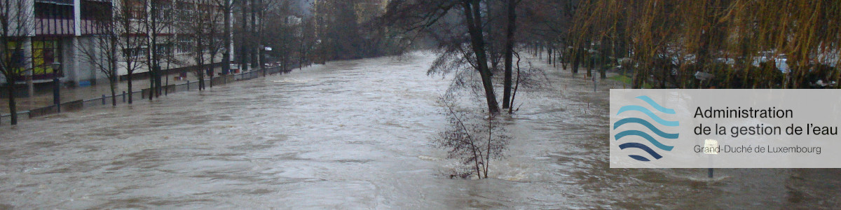
The flood warning service is in alert status. Risk of major floods, causing large inundation that could have a significant impact on people and property; even in areas that are rarely flooded. Updates at least twice daily or by change of situation.
Significant danger Friday 17.05.2024 and Saturday 18.05.2024
Due to the further increase in rainfall over the last few hours, the water levels at some watercourses are rising significantly more than expected.
On the Alzette, the water levels have already exceeded the "cote d'alerte" at the Pfaffenthal and Steinsel gauges, and the Mersch gauge is expected to continue to exceed the "cote d'alerte" from this evening.
On the Alzette, the "cote d'alerte" may also be exceeded at the Ettelbrück gauge; the maximum levels on the Alzette are expected to be reached during the night/morning.
On the Sûre, an exceedance of the "cote de préalerte" at the Diekirch and Bollendorf gauges can no longer be ruled out from late evening/at night; the maximum levels will be reached in the morning.
Some smaller water courses (Mamer, Syre, Ernz Blanche and Ernz Noire) have also reached significantly higher water levels; as with all water courses, increased caution still applies here. The maximum levels on the smaller water courses are currently being reached or will be reached in the next few hours.
Update if situation changes.
A flood report is available for Luxembourg (without Moselle):
Flood Report Luxembourg (without Moselle) (PDF)
Auswirkungen & Empfehlungen
Mögliche Auswirkungen
- Weitreichende Überschwemmungen, die das wirtschaftliche Leben und die Aktivitäten der Menschen über mehrere Tage beeinträchtigen können.
- Großräumige Überschwemmungen, auch in Gebieten, die selten überflutet werden.
- Sehr schwere Straßenverkehrsbedingungen.
- Gefahr des Überlaufs von Kanalisationsnetzen.
Verhaltensempfehlungen
- Vergewissern Sie sich, dass Sie die Empfehlungen der Warnstufe Orange umgesetzt haben.
- Bleiben Sie wenn möglich zu Hause und verfolgen Sie weiterhin die aktuellen Hochwasserwarnungen auf www.inondations.lu, Wetterwarnungen auf www.meteolux.lu, beziehungsweise im Radio oder Fernsehen.
- Vermeiden Sie jeglichen unnötigen Aufenthalt in den betroffenen Gebieten.
- Falls Sie unbedingt irgendwohin fahren müssen, seien Sie äußerst vorsichtig und setzen Sie Ihre Angehörigen von Ihrer Abfahrt und Ihrem Zielort in Kenntnis.
- Folgen Sie Umleitungen und beachten Sie gesperrte Straßen.
In hochwassergefährdeten Gebieten
- Vermeiden Sie unter allen Umständen Uferbereiche, überflutete Straßen und Wege.
- Ist der Strom ausgefallen oder abgestellt, nutzen Sie batteriebetriebene Geräte wie Ihr Smartphone, ein batteriebetriebenes Radio oder das Autoradio.
- Begeben Sie sich nicht in überschwemmungsgefährdete Räume (Keller, Garagen - Achtung vor Stromschlägen).
- Erleichtern Sie die Arbeit der Einsatzkräfte, die Ihnen eine Evakuierung vorschlagen, und beachten Sie deren Ratschläge, um weder Ihr Leben noch das der Einsatzkräfte in Gefahr zu bringen.
- Bleiben Sie ruhig und handeln Sie überlegt; Menschenrettung geht vor Erhaltung von Sachwerten.
- Bitte beachten Sie, dass die Feuerwehr während des Hochwassers keine Pumpen in überfluteten Räumen einsetzt bzw. zur Verfügung stellt. Das Auspumpen während des Hochwassers könnte zu unterschiedlichen Druckverhältnissen führen und Wände beschädigen.
Moselle
Currently no risk of floods.